


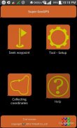

Super GeoGPS
Descrizione di Super GeoGPS
This is the best tool for those working in surveying, mapping, construction, transportation, planning... It supports high precision GPS and Glonass navigation in fieldwork surveys.
This tool is designed for Civil Engineer, Surveyor, Civil Surveyor, Land Surveying and Topografia
The typical functions of Super GeoGPS:
★ Super GeoGPS: Available many common reference systems, allows to set up more other reference systems.
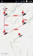
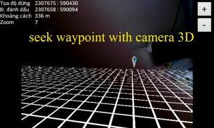
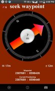
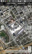
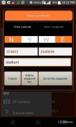
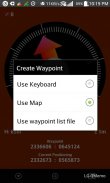
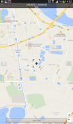
★ Super GeoGPS: Easy to finding waypoint on any reference coordinate systems by display direction, compass, distance, load Google maps. (for Civil Engineer and Surveyor)
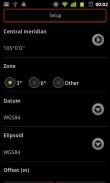
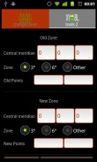
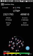
★ Super GeoGPS: Easy to use 7 transformations parameters in order to automatically convert between Geographic and UTM Coordinates. Synchronize Google map with UTM zone.
★ Super GeoGPS: Support convert between Geographic and UTM coordinates. Convert UTM coordinates between different zone.
★ Super GeoGPS: Measuring current waypoint high precision. Routing and automatically collect coordinates on the way by cycle preset then create a text file coordinates to easily attach to email or export to your computer.
★ Super GeoGPS: Avoid stray is tool will marking point along the way and shows direction to come back, It support those who take the survey in the forests and mountains, sea, or traveling.
★ Super GeoGPS: Support GPS and Glonass
- Geological Compass tool
- Management of waypoint file (multi waypoint file)
- Export waypoint file to excel or text file
- Touch on Google map to add point
- Calculate the area (2D)
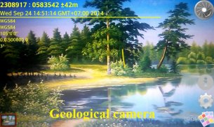
- Geological camera
- Compass adjustment
★ Super GeoGPS
- Fast config
- Add all of WGS84 central meridian.
- Tools for measuring distance between 2 devices
★ Super GeoGPS - Geodetic coordinates/UTM with:
- WGS1984
- WGS1972
- NAD1983/1927
- VN2000, HN1972
- Austria NS
- Belgium 50
- Nouv Trig de France 1
Super GeoGPS support 6 common language in the world (English, French, Chinese, Russia, Spanish and Vietnamese)
Questo è il miglior strumento per chi opera nel rilevamento, mappatura, costruzioni, trasporti, pianificazione ... Supporta alta precisione GPS e navigazione Glonass nelle indagini lavoro sul campo.
Questo strumento è progettato per Ingegnere Civile, Geometra, Perito civile, Topografia e Topografia
Le funzioni tipiche di GeoGPS super:
★ GeoGPS super: disponibili molti sistemi di riferimento comuni, permette di configurare più altri sistemi di riferimento.
★ Super GeoGPS: facile da trovare waypoint su qualsiasi riferimento sistemi di coordinate dalla direzione di visualizzazione, la bussola, la distanza, caricare le mappe di Google. (Per ingegnere civile e Surveyor)
★ Super GeoGPS: Facile da usare 7 parametri trasformazioni al fine di convertire automaticamente tra geografica e UTM. Sincronizzare Google map con zona UTM.
★ Super GeoGPS: Supporto convertire tra geografica e UTM. coordina Convertire UTM tra zona diversa.
★ Super GeoGPS: Corrente di misura waypoint di alta precisione. Routing e automaticamente raccolgono le coordinate sulla strada da preimpostato ciclo quindi creare un file di testo le coordinate per collegare facilmente a e-mail o esportare al computer.
★ GeoGPS super: Evitare randagio è strumento marcatura punto lungo la strada e mostra la direzione di tornare, Sostiene quelli che prendono l'indagine nelle foreste e montagne, mare, o in viaggio.
★ Super GeoGPS: Supporto GPS e GLONASS
- Strumento geologica Compass
- Gestione dei file di waypoint (file a più waypoint)
- Esporta file waypoint di Excel o file di testo
- Toccare sulla mappa di Google per aggiungere il punto
- Calcolare l'area (2D)
- Fotocamera geologica
- Regolazione della bussola
★ Super GeoGPS
- Config veloce
- Aggiungere tutti WGS84 meridiano centrale.
- strumenti per misurare la distanza tra i 2 dispositivi
★ Super GeoGPS - coordinate geodetiche / UTM con:
- WGS1984
- WGS1972
- NAD1983 / 1927
- VN2000, HN1972
- Austria NS
- Belgio 50
- Nouv Trig de France 1
GeoGPS Super supporto 6 linguaggio comune nel mondo (inglese, francese, cinese, Russia, spagnolo e vietnamita)
Super GeoGPS - Versione 6.0
(20-05-2020)Super GeoGPS - Informazioni APK
Versione APK: 6.0Pacchetto: com.truonghau.compassUltima versione di Super GeoGPS
Altre versioni


App nella stessa categoria

Potrebbe piacerti anche...


